NOTE!
These results are primarily presented in order to demonstrate
how "patchy" data may be filled, some of the criteria that might
be applied, and some of the implications that such a procedure
has on the extrapolated product. The extrapolated product that
will ultimately be examined in NOClim's PT 5 will be
presented elsewhere.
When a time series analysis is conducted, it is of large value to have a homogeneous set of results or data. Unfortunately, the COADS SST data does not fulfill such a requirement, since the set contains "holes", i.e., there are a number of grids where values are lacking for some months. This problem occurs more frequently in some regions than in others. In order to attain a homogeneous set, we first restrict the "wet" domain, and then fill in the holes by extrapolation in space:
- Set the land-sea grid, by requiring the following criteria for a grid to be (considered) wet:
- a minimum number of occurences as wet (in percent) for an occasionally missing grid ("minimum occurence")
- when missing, a grid must be within a maximum distance to a wet grid ("maximum distance", either in longitude or latitude)
- Fill all missing grids for each horizontal field, by applying an iterative Laplacian solver to missing grids, with von Neumann's boundary condition. Use the mean value of all (initially) wet grids as the first guess for the missing nodes.
- Reset the land-sea mask occording to the result from 1. above.
The first part of the COADS analysis is to set the "wet domain", and to "fill in" the "wet" missing values by extrapolation. In order to understand how the citeria in 2. above affect the size of the "wet domain", a number of choices were made:
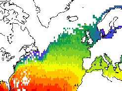
Original data.In the figure to the right, the original results for January 1960 are displayed. We note that information in the Nordic Sea is available in the Southern Norwegian Sea only, and that the results are "patchy" in a few regions. |
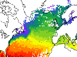
|
Case 1.In the figure to the right, the filled and masked results for January 1960 are displayed. We note that almost the entire Nordic Sea is considered "dry" using the present requirements. Missing values are also abundant in the Nortwestern Atlantic. Elsewhere, the coverage is satisfactory. |
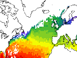
|
Case 2.The results depicted to the right were obtained similarly to Case 1, the only exception being a less strict requirements for minimum occurence. However, we note that the "wet domain" is almost identical to the Case 1 result. |
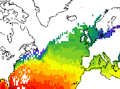
|
Case 3.The results depicted to the right were obtained similarly to Case 1, the only exception being a less strict requirements for maximum distance. Here, the size of the "wet domain" has expanded, in a belt from Newfoundland to Iceland, when compared to the Case 1 result. |
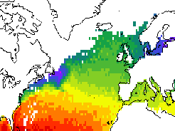
|
Case 4.The results depicted to the right were obtained similarly to Case 1, the only exception being that results from the 1960s and 1970s were disregarded. (The figure displays the filled and masked results for Janyuary 1980). The size of the "wet domain" is somewhat larger than in Case 1, notably Southwest of Iceland and along the Norwegian coast. |
|