1. Background and motivation
The inflow of warm and saline Atlantic Water (AW) to the Nordic Seas by the Norwegian Atlantic Current (NAC) is a crucial factor in maintaining the anomalously (relative to latitude) warm climate of Northern Europe.
The present understanding of the NAC is that it occurs as a well defined two-branch system; an eastern branch situated just off the shelf break and a western branch as an extension of the Iceland-Faroese Front (e.g. Poulain et al., 1996; Orvik et al., 2001). AW flux estimates (S>35.0) are about 4.5 Sv in the eastern branch and about 3.5 Sv in the western branch. In terms of fluxes of heat and salt the differences is somewhat larger since the eastern branch is slightly warmer/saltier compared to the western branch.
Even though the basic structure of the NAC is known its main driving mechanism is under debate. This question is of importance because the driving mechanism may provide different constraints on the stability and the variability of the system. The question also certainly depend on the time scales of consideration. On time scales from a few days upto weeks the eastern branch of the NAC is closely linked to the wind forcing (Skagseth and Orvik, 2000). However on the seasonal and longer time scales separating the wind and thermohaline forcing is more difficult (Hansen and Ïsterhus, 2000; Orvik et al., 2001). An other question of importance is on the relative distribution of the eastern and western branch of the NAC. What forcing determines the strength of the two branches of the NAC and is there phase relationship between strength of these? These questions are central in order to understand the exchanges between North Atlantic and the Norwegian Sea and are of relevance for the climate in the Nordic - and Arctic Seas.
A specific motivation for this note is found in the current meter records in the eastern branch of the NAC. Continuous measurements of the NAC is performed since april 1995. The record show a marked seasonality with respectively winter and summer maxima and minima (Fig. 1). The record is positively correlated with the strength of the westerlies throughout the record except for the first year (Orvik et al., 2001). In summer of 1995 the strength of the eastern branch is anomalously high and is not explained (at least in a simple manner) by the wind field. In this note some complementary data set is analysed in order to understand the observed variability. The focused time scales range from months to inter-annual.
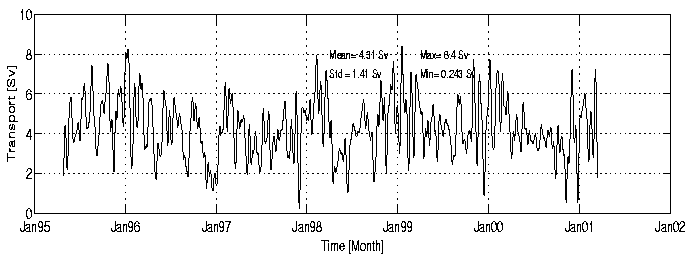
Figure 1. Atlantic water transport in the eastern branch of the Svin°y section. One week moving averaged values.
2. Data sets
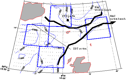
Figure 2. Map of the investigation area including schematic of the NAC, (*) indicates altimeter points, XBT section in the northen North Atlantic, and CTD profile north of the Faroes Isl. The boxes to calculate sea surface slope shown in figure 8. |
In order to understand the observed variability found in the NAC data sets representing the forcing field and ocean state in the region of the Scotland-Iceland Ridge are analysed (Fig. 2).
The forcing field is represented by the mean sea level pressure (mslp) field from the DNMI reanalysis at spatial resolution of 75 km by 75 km at 6 hour time interval.
Sea surface height is from the TOPEX altimeter data. The record cover the period from fall 1992 to date. The data set considered here is at 0.5 deg by 0.5 deg spatial resolution at 10 days time interval. The mean state is subtracted at each grid point thus only information on the variability is contained in the data.
The hydrographic variability north of the ridge is from a repeated profile in the standard section north of the Faroese Isl. (data obtained from Bogi Hansen). Variability south of the Faroese-Island Ridge is represented by repeated XBT sections (data from IFREMER) in the falls of 1994, -95, -96 and -97. These sections contain temperature information only, but known regional TS relations can be considered to reduce this problem.
3. Analysis of variability
3.1 Sea surface height variability
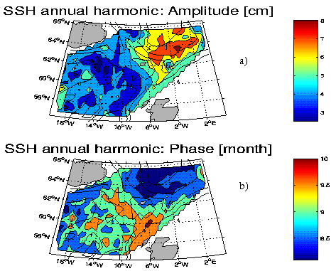
Figure 3. Analysis of the sea surface height annual cycle showing a) amplitude in cm and b) phase in month. |
The ssh variability from the TOPEX satellite data in the Iceland-Scotland Ridge is considered in this study. The seasonality in the data is retrieved by a simple harmonic analysis (Fig. 3). The analysis indicate show larger amplitudes in the Norwegian Sea compared to the North Atlantic, and with the corresponding phase varying by less than a month. Since the TOPEX data only captures variability of the mean, this physically means that the general sloping sea surface across the Iceland-Scotland Ridge is at maximum in March and at minimum in September. In terms of magnitude this variability is of comparable size to the large scale sea surface slope in the Atlantic Ocean of the order 10-7 m/m.
To investigate the temporal variability in the ssh an eof analysis is performed (Fig 4). The two leading eof modes are statistically significant and captures 24.5 and 6.3 % of the variability. Note that the magnitude of explained variance depend strongly on the size of the considered area and time filtering applied prior to the analysis.
Eof mode 1 shows a monopole pattern with the higher magnitudes in the Norwegian Sea and with the principal component revealing a strong seasonal signal. This is in accordance with the results of the harmonic analysis. Additionally this mode show two more long-periodic trends with possible growing amplitude, from 1993-1995 and from 1996-1999, and separated by a "jump" in 1995.
Eof mode 2 describes a dipole with nodal line at the Iceland-Faroese Ridge and turning northeastward into the Norwegian Sea. Thus this mode possible contain information on the two branches of the NAC. The associated principal component show prominent fluctuations for the period 1995-96, whereas the amplitudes are smaller for the remaining period. (The mode also show prominent fluctuations prior to 1995 but for this period no current measurements were available).
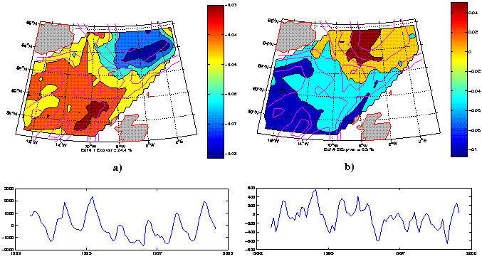
Figure 4. Eof analysis og the SSH variability a) first mode and b) second mode. Three month low-pass filtered data.
3.2 The mean sea level pressure data
The variability of the mslp data show that the first eof mode explain about 51.2 % of the variability (Fig. 5). Combined with the principal component the eof pattern basically represents the strength of the westerlies, with winter maxima and summer minima. Also noteworthy is the "switch" in state between 1995 and 1996, and the apparent long-periodic trends with possible growing amplitude for the periods 1992-1995 and 1996-2000. Of the higher modes the third eof is shown because the eof pattern appear effective in forcing water over the Scotland-Iceland Ridge and the principal component show the maximum variability during 1995-96. This coincide with the period of anomalous current in the NAC (Fig. 1).
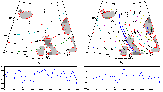
Figure 5. EOF analysis of Hindcast MSLP data a) first mode and b) third mode. Three month low-pass filtered data.
3.3 Hydrography
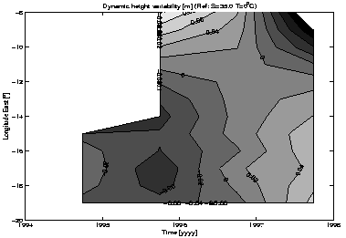
Figure 6. Steric height anomaly based on XBT temperature section between Scotland and Iceland. |
For comparison with the TOPEX ssh data estimates of the steric height variability are made based on hydrographic measurements. The steric height variability based on four repeated section from 1994 to 1997 between off North-Scotland and Iceland indicate rather substantial variability (Figure 6). On the western part of this section there are negative anomalies for the years 1994 and 1995 and a transition toward positive anomaly in 1997. The values range from -0.06m to 0.04m. The eastern part show an opposite trend with positive values in 1995 and transition to negative values in 1997. The anomalies appear somewhat higher in the eastern compared to the western part of the section. Note that these estimates are based on the assumption of a constant salinity of 35.0 psu. The in general positive correlation between salinity and temperature in this region means that the steric height variability are probably overestimated.
The steric height variability north of the Faroese Isl. at 64°00'N and 6°05'W show a marked seasonal cycle (Fig 7). Relative to the annual harmonic the year 1995 appear normal whereas but with negative values from the summer 1996 to summer the 1998.
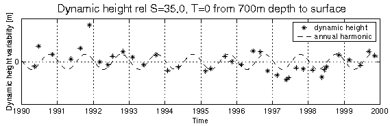
Figure 7. Estimates based on a CTD station north of the Faroes at 64°00'N, 6°05'W showing the steric height anomaly as ( * ) for the observed profiles and a annual harmonic fit to steric height anomaly as ( - - )
4. Discussion (preliminary)
Having the observed variabilities in NAC, ssh, hydrography and the wind forcing (mslp) it is natural to question the mechanism of their coupling. The answers to this is at present rather open but will be focused in the further study. In the following some of the possible relations and mechanisms will briefly be pointed out.
The analysis indicate a close relation between the mslp and the ssh fields. The principal component (time series) of these two fields (Figs. 4a and 5a) show clear similarities; two trends of duartion of several years and "jump" in 1995. The variability in ssh trail the variability in mslp with a few months. The physical interpretation of these modes is that during strong westerlies the in general downward sea surface slope (sss) from the North Atlantic to the Norwegian Sea becomes steeper. The westerlies are in general stronger during wintertime, and if the sea surface slope reflects the strength of the NAC, this is an indication of a systematically stronger NAC in winter compared to summer. Comparison with the NAO index indiacte a closer relation to the sss in the eastern (along the continental slope) branch of the NAC compared to the western (across the Iceland-Faroese Ridge) branch of the NAC (Fig. 8).
The Topex ssh data indicate a negative ssh anomaly in the North Atlantic and positive anomaly in the Norwegian Sea from summer 1995 an lasting about one year, followed by anomalies of opposite sign in the subsequent years. The XBT section in the North Atlantic indicate that these anomalies are at least parts to change in the hydrography. However it is not clear whether this variability is generated locally by e.g. anomalous ekman pumping due to anomalous wind forcing or if it is due to advection.
Independent of origin the effect on the NAC of cold anomalies in the North Atlantic between Island and Faroese Isl. can be discussed. Under the assumption that the western branch of the NAC is associated with the Iceland-Faroese Polar Front extending into the Norwegian Sea the transport (and velocities) depend on the density difference between the light Atlantic Water an the denser Polar Water, and the thickness of the Atlantic layer. The cold anomaly in 1994-95 on the warm side of the front means a reduced cross front density gradient and thus reduced transport in this branch. This does however not provide any direct link to strength of the eastern branch of the NAC, but needs some assumption e.g. that the total NAC is constant.
Anomalies in the northern North Atlantic do however also affect the meridional density gradient to the south of the anomalies. For the cold anomaly in 1994-95 this would increase the eastward geostrophic current toward the continental slope where it transfers into a northward slope current , i.e. the eastern branch of the NAC in the Norwegian Sea. Such argumentation provide a direct link between cold anomalies in the northern North Atlantic as observed in 1994-95 and the observed anomalously strong eastern branch the NAC during 1995. Similar argumentation would also work for warm anomalies but with opposite sign.
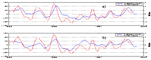
Figure 8. Sea surface slope variability from the North Atlantic into the Norwegian Sea in a) the eastern and b) the western part.