| Effect research |
| Explanations |
| Empirical downscaling |
| Dynamical downscaling |
| Observations |
| Analyses |
| Models |
Explanations
Below we will explain what the basic concepts are in the climate effects research program.
The most powerful tools in modern climate research are known as General circulation models (GCMs), they are computer models that simulate large-scale climate conditions and are used to project future climate changes. The greenhouse effect is known as a forcing effect on the global climate, so much research is made to investigate the effect on different parts of the globe. The GCMs have a coarse spatial resolution, typically about 100-400 km, so GCMs cannot predict changes on smaller parts of the world. For practical applications and impact studies local climate variables such as temperature and precipitation are wanted. To predict climate on a local scale, other methods must be used. Downscaling refers to a suite of methods by which local climate variables can be obtained from the large-scale variables provided by a GCM.
Empirical downscaling
Empirical downscaling is also known as statistical downscaling.
The basic thesis is that the local climate can be found as a function of the global climate and local physiography:
Local climate = f(global climate, local physiography)
In any given place there is thus a connection between global and local climate. The connection, or function, is found by statistical analyses of historical data (see Observations): Large-scale atmospheric circulation patterns are correlated with typical patterns of regional climate parameters, the resulting functions are then used on results from global climate models.
The main parameter in the function is called the predictor, often the ground pressure is used as a predictor.
Results that are calculated will typically be temperature and precipitation.
Dynamical downscaling
A dynamical downscaling is performed by running a climate model on a small local part of the globe, where the local part is more detailed than the typical global models used. Typical resolution for the local model is from 10 to 50 km. This means that geograpic features as mountains and coastlines are better represented, which leads to more accurate simulation of precipitation, temperature and cloud formation compared to the global model. Values at the edges of the local model are retrieved from the more coarse global models, for the same time series. Thus global weather patterns are "downscaled".
Observations
Measurements of actual weather is termed "observations". Although humans have always depended on weather, accurate measurements of temperature, atmospheric pressure and precipitation (to name the most important) are not recorded on a larger scale until about 1860.
The observed weather is important in climate models, as observations are used to calibrate the models and to verify that the models are realistic. Many climate models are starting the analysis by recreating the weather from as early as 1860. For a dynamic downscaling this means that the computed weather can be compared to the actual weather. For an empiric downscaling, the observations are crucial for calculation of the downscaling functions.
Analyses
Analysis is the process of converting observations, which are geographically distibuted quite randomly over the world, into a regular grid of numbers. The analysis interpolates observations and makes the numbers and positions fit the prediction model.
Models
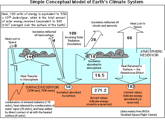
Most climate analyses are based on numeric weather prediction models, which work by dividing the atmosphere into cubes, such that each cube will experience uniform weather conditions. Each cube will in turn influence the neighbour cubes. The analysis will then continue in time-steps to resolve how weather evolves, based on equations that simulate heat exchange, air circulation, etc. More analysis models are being introdused, to include effects of sea-ice, seawater currents and atmospheric chemistry to name a few.

An example of the global heat exchange model
Further reading:
Numerical modelling, Norwegian Meteorological Institute
The climatologist's toolbox, University of Wisconsin
Weather Forecasting: online meteorology guide, University of Illinos.
Send comments to webmaster