
|
| Home -> History Polar Lows -> History | |
|
Polar Low Cases The Rescue Deed of Hamningberg Torsvaag 31 Oct 2001 Polar Low 24 Oct 2012 Polar Low 06 Feb 2012 |
The Torsvåg stormThe Thorsvåg storm was one of only two in modern history where life was lost. A violent and sudden storm erupted outside the Vannøya island with its community Thorsvåg. One boat capsized, and one of its two man crew was lost to the seas. (NOAA-16/met.no)
Picture 1. shows the low in its incipient stage, as an enhanced cloud structure off the coast of Troms, embedded along a shallow frontal zone parallel to the coastline. The models in this case did show a rather poor performance. It is thus difficult to precisely say the nature of the cloud structure, and what kind of instability was present. The low cloud top temperature and the wavelike structure in the overlying cirrus shield does imply that the low already in this stage had a substantial degree of both baroclinic and convective instability. 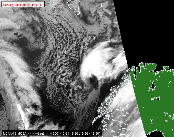
Picture 2 is the last seen at the forecasting center in Tromsø before the night shift, and the long lapse in satellite coverage that at that time lasted till approximately 2a.m. In the morning. The low is now clearly developed, and shows the typical features of a polar low in its early stages, with a clear and almost cloud free eye and the smooth cirrus cap around the center. (NOAA-15/met.no) 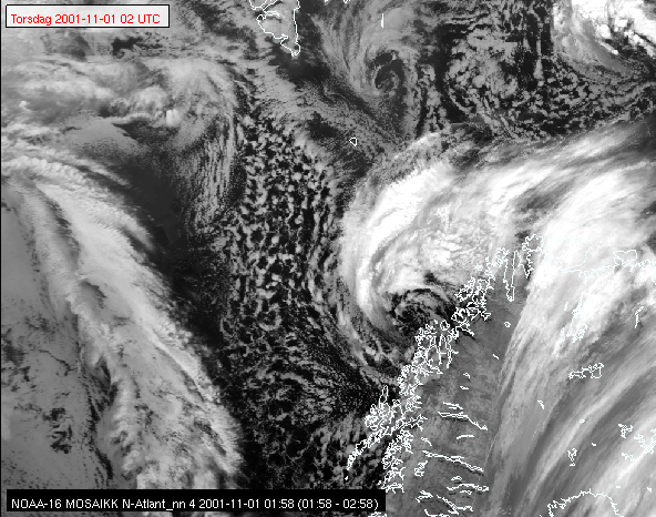
Picture 3, a mature polar low just outside the coast of northern Troms. The eye is now less clear, with some isolated cumuliform clouds and bands of lower stratiform clouds in the near vincinity of the center. The lower cloud tops here may be a signature of the very low tropopause, in some cases down to 10.000 feet, that can be seen in such cases. The cloud bands leading away from the center seems to be dividing into several individual cloud structures, possibly indicating less homogeneous flow around the center. (NOAA-16/met.no) 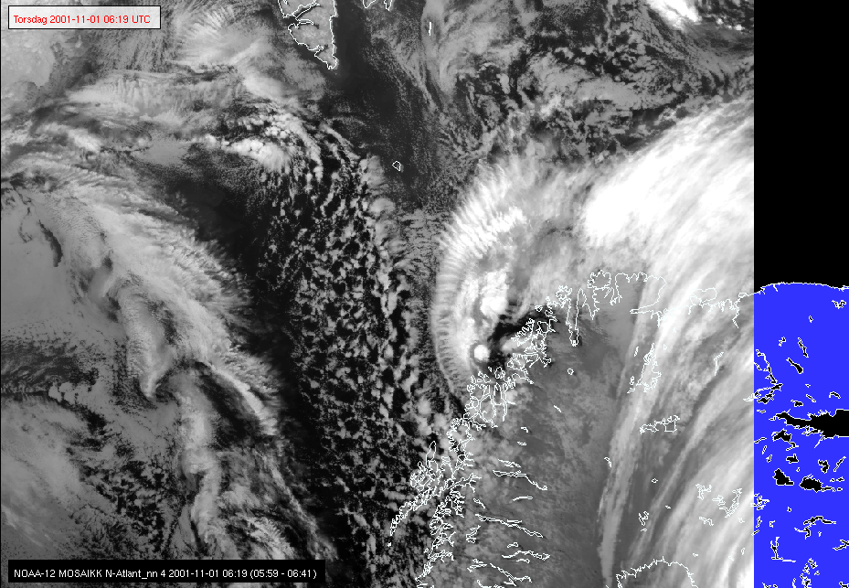
Picture 4. The Torsvåg low at the Hirlam 10km model time of the accident, showing the appearance of a highly dynamic low. The wavelike structure in the cirrus shield is typical for cases with strong surface wind, probably indicating a deep layer of vertically rising air from the surface, and strong vertical shear at the top of this ascending air. (NOAA-12/met.no) 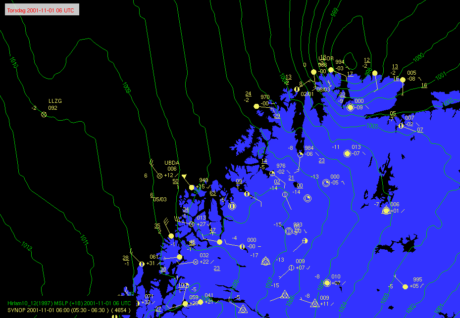
Picture 5. The MSLP field from the HIRLAM 10km NWP models used at the forecast center at the time, overlaid observations from 06z on the 1st of November 2001. The observations show a very local area with storm force winds at the coast of Northern Troms, as observed from the then still manned lighthouse at Torsvåg with past max winds of 50kts, and gusts of 63kts. Note also that there were no observations for a very long distance northeastwards along the coast at this early time of the day, and thus a difficult task to make a good assessment of the situation. The prognostic model field of MSLP indicated a polar low developing at the East Finnmark coast some 370km further east on the morning of the 1st, but as the observations indicate, this was clearly not the case. Such an erratic positional error in the NWP model was more the rule than the exeption with polar lows or other meso scale phenomena at the time. Nevertheless, it probably was the main focus for the forecaster at the time. 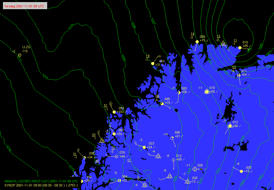
Picture 6 from 09z also illustrates a typical aspect of the polar low, -the moderate negative pressure tendencies and rather weak winds to the front of the low, and strong positive pressure tendencies and strong northerly wind at the rear of the low. At 9z the tendency was +10,3hPa/3hr at the Torsvåg lighthouse, and at 12z the MSLP was still rising by 5.0hPa/3hr. The surface air is not necessarily very cold in events of polar lows. Rather, at the surface, Polar Lows bring relatively mild marine air that has been heated by the ocean on its long journey from Arctic ice to the Scandinavian coast. As can be seen from the observation from the Torsvåg lighthouse, the temperature was a relatively mild +1 degree centigrade with light showers of sleet or rain at the time of the event. Although Polar Lows are described as a cold weather phenomena, this relates to the relatively low temperatures and at middle and higher altitudes. |
| Updated March 6. 2013 Editor Yvonne Gusdal | |

|
|