
| Effect research |
| Dynamical downscaling |
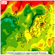
| Model Results |
| Data |
| Refined Results ... |
![]()
![]()
| Main | Maps | Data | Contact | RegClim |
The data are available in two formats, (1) netcdf covering the full HIRHAM domain and (2) ascii tables (csv) covering Nordic landpoints. The netcdf format was adopted for exchange of data between regional climate research senters in Europe, including impact modellers, and is easiest accessable on unix/linux platforms. The ascii tables provides the data in a format hopefully useful for Norwegian impact modellers working on MS windows systems, and may be imported into e.g. MS excel. The csv-files have been compressed with the linux gzip command.The csv-files can be downloaded from this page, while the netcdf-files will be made available for ftp-transfer on request (see contact page).
 Daily values from HIRHAM simulations with the following global forcing data:
The Hadley Centre A2 and B2 scenarioes have common control data.
Hadley Centre data in netcdf-format:
| Par | Name | Unit | Size | CN 1961-1990 | A2 2071-2100 | B2 2071-2100 |
|---|---|---|---|---|---|---|
| t2m | 2-meter temperature | K | 312Mb | t2m.HADCN.nc | t2m.HADA2.nc | t2m.HADB2.nc |
| precip | Precipitation | kg/m2/day | 312Mb | precip.HADCN.nc | precip.HADA2.nc | precip.HADB2.nc |
| clcov | Total cloudiness | [0-1] | 312Mb | clcov.HADCN.nc | clcov.HADA2.nc | clcov.HADB2.nc |
| evap | Evaporation | kg/m2/day | 312Mb | evap.HADCN.nc | evap.HADA2.nc | evap.HADB2.nc |
| snow | Snow water equivalent | mm | 312Mb | snow.HADCN.nc | snow.HADA2.nc | snow.HADB2.nc |
| runoff | Total runoff | kg/m2/day | 312Mb | runoff.HADCN.nc | runoff.HADA2.nc | runoff.HADB2.nc |
| Psurf | Surface pressure | hPa | 312Mb | Psurf.HADCN.nc | Psurf.HADA2.nc | Psurf.HADB2.nc |
| MSLP | Mean sea level pressure | hPa | 312Mb | MSLP.HADCN.nc | MSLP.HADA2.nc | MSLP.HADB2.nc |
| t2max | Daily maximum 2-meter temperature | K | 312Mb | t2max.HADCN.nc | t2max.HADA2.nc | t2max.HADB2.nc |
| t2min | Daily minimum 2-meter temperature | K | 312Mb | t2min.HADCN.nc | t2min.HADA2.nc | t2min.HADB2.nc |
| w10m | 10-meter windspeed | m/s | 312Mb | w10m.HADCN.nc | w10m.HADA2.nc | w10m.HADB2.nc |
| w10max | 10-meter daily maximum windspeed | m/s | 312Mb | w10max.HADCN.nc | w10max.HADA2.nc | w10max.HADB2.nc |
| t2d | 2-meter dewpoint temperature | K | 312Mb | t2d.HADCN.nc | t2d.HADA2.nc | t2d.HADB2.nc |
| SWnet | Net SW radiation | W/m2 | 312Mb | SWnet.HADCN.nc | SWnet.HADA2.nc | SWnet.HADB2.nc |
| SWdown | Downward SW radiation | W/m2 | 312Mb | SWdown.HADCN.nc | SWdown.HADA2.nc | SWdown.HADB2.nc |
| LWnet | Net LW radiation | W/m2 | 312Mb | LWnet.HADCN.nc | LWnet.HADA2.nc | LWnet.HADB2.nc |
| LWdown | Downward LW radiation | W/m2 | 312Mb | LWdown.HADCN.nc | LWdown.HADA2.nc | LWdown.HADB2.nc |
Max Planck Institute data in netcdf-format:
| Par | Name | Unit | Size | CN 1961-1990 | B2 2071-2100 |
|---|---|---|---|---|---|
| t2m | 2-meter temperature | K | 312Mb | t2m.MPICN.nc | t2m.MPIB2.nc |
| precip | Precipitation | kg/m2/day | 312Mb | precip.MPICN.nc | precip.MPIB2.nc |
| clcov | Total cloudiness | [0-1] | 312Mb | clcov.MPICN.nc | clcov.MPIB2.nc |
| evap | Evaporation | kg/m2/day | 312Mb | evap.MPICN.nc | evap.MPIB2.nc |
| snow | Snow water equivalent | mm | 312Mb | snow.MPICN.nc | snow.MPIB2.nc |
| runoff | Total runoff | kg/m2/day | 312Mb | runoff.MPICN.nc | runoff.MPIB2.nc |
| Psurf | Surface pressure | hPa | 312Mb | Psurf.MPICN.nc | Psurf.MPIB2.nc |
| MSLP | Mean sea level pressure | hPa | 312Mb | MSLP.MPICN.nc | MSLP.MPIB2.nc |
| t2max | Daily maximum 2-meter temperature | K | 312Mb | t2max.MPICN.nc | t2max.MPIB2.nc |
| t2min | Daily minimum 2-meter temperature | K | 312Mb | t2min.MPICN.nc | t2min.MPIB2.nc |
| w10m | 10-meter windspeed | m/s | 312Mb | w10m.MPICN.nc | w10m.MPIB2.nc |
| w10max | 10-meter daily maximum windspeed | m/s | 312Mb | w10max.MPICN.nc | w10max.MPIB2.nc |
| t2d | 2-meter dewpoint temperature | K | 312Mb | t2d.MPICN.nc | t2d.MPIB2.nc |
| SWnet | Net SW radiation | W/m2 | 312Mb | SWnet.MPICN.nc | SWnet.MPIB2.nc |
| SWdown | Downward SW radiation | W/m2 | 312Mb | SWdown.MPICN.nc | SWdown.MPIB2.nc |
| LWnet | Net LW radiation | W/m2 | 312Mb | LWnet.MPICN.nc | LWnet.MPIB2.nc |
| LWdown | Downward LW radiation | W/m2 | 312Mb | LWdown.MPICN.nc | LWdown.MPIB2.nc |
Hadley Centre data in csv-format (ascii):
Max Planck Institute data in csv-format (ascii):
| Par | Name | Unit | Size | CN 1961-1990 | B2 2071-2100 |
|---|---|---|---|---|---|
| t2m | 2-meter temperature | K | <10Mb | t2m.MPICN.csv | t2m.MPIB2.csv |
| precip | Precipitation | kg/m2/day | <10Mb | precip.MPICN.csv | precip.MPIB2.csv |
| prsnow | Snowfall | kg/m2/day | <10Mb | prsnow.MPICN.csv | prsnow.MPIB2.csv |
| clcov | Total cloudiness | [0-1] | <10Mb | clcov.MPICN.csv | clcov.MPIB2.csv |
| evap | Evaporation | kg/m2/day | <10Mb | evap.MPICN.csv | evap.MPIB2.csv |
| snow | Snow water equivalent | mm | <10Mb | snow.MPICN.csv | snow.MPIB2.csv |
| runoff | Total runoff | kg/m2/day | <10Mb | runoff.MPICN.csv | runoff.MPIB2.csv |
| Psurf | Surface pressure | hPa | <10Mb | Psurf.MPICN.csv | Psurf.MPIB2.csv |
| MSLP | Mean sea level pressure | hPa | <10Mb | MSLP.MPICN.csv | MSLP.MPIB2.csv |
| t2max | Daily maximum 2-meter temperature | K | <10Mb | t2max.MPICN.csv | t2max.MPIB2.csv |
| t2min | Daily minimum 2-meter temperature | K | <10Mb | t2min.MPICN.csv | t2min.MPIB2.csv |
| w10m | 10-meter windspeed | m/s | <10Mb | w10m.MPICN.csv | w10m.MPIB2.csv |
| w10max | 10-meter daily maximum windspeed | m/s | <10Mb | w10max.MPICN.csv | w10max.MPIB2.csv |
| t2d | 2-meter dewpoint temperature | K | <10Mb | t2d.MPICN.csv | t2d.MPIB2.csv |
| SWnet | Net SW radiation | W/m2 | <10Mb | SWnet.MPICN.csv | SWnet.MPIB2.csv |
| SWdown | Downward SW radiation | W/m2 | <10Mb | SWdown.MPICN.csv | SWdown.MPIB2.csv |
| LWnet | Net LW radiation | W/m2 | <10Mb | LWnet.MPICN.csv | LWnet.MPIB2.csv |
| LWdown | Downward LW radiation | W/m2 | <10Mb | LWdown.MPICN.csv | LWdown.MPIB2.csv |
Description of file format netcdf:
The present netcdf format was coded as specified in the EU-project PRUDENCE. See their data distribution page for further information. The files contains daily data for the full HIRHAM model domain except the outer boundary zone of 5 gridpoints (used for relaxation towards the global forcing fields). The main source of information about netCDF is the netCDF homepage http://www.unidata.ucar.edu/packages/netcdf/index.html. Many software links are provided on the netCDF homepage. For Unix platforms you may especially check out the browser "Ncview" and the manipulating software "NCO" which allows you to perform easily arithmetics on the netCDF file and change attributes. Ferret is recommended for displaying with more options than ncview.
Description of file format csv (ascii):
The data in this format was created for easier access to daily values for use in e.g. impact studies. The ascii table format can be imported in e.g. MS Excel without difficulties. The subset of gridpoints from the total HIRHAM integration area is shown in this figure. The files contain data for 444 gridpoints selected within the Nordic area (Norway, Sweden, Finland and Denmark), for landpoints where the HIRHAM gridcells are covered with more that 40% land (in the figure landareas inside the solid black line). Gridpoints are selected in a geographical region bounded by longitute=[2.5,32.5] and latitude=[54.0,72.5]. The southeast corner longitude=[20,32.5], latitude=[54.0,59.0] is not included.
| Line no. | Name | Description |
|---|---|---|
| 1 | LONGITUDE | Longitude position of gridcell in desimal degrees |
| 2 | LATITUDE | Latitude position of gridcell in desimal degrees |
| 3 | TOPOGRAP | Model height above sea level in meter |
| 4 | FRACLAND | Fraction of land in gridcell in % |
| 5 | X-COORDI | Gridpoint number in x-direction (see figure) |
| 6 | Y-COORDI | Gridpoint number in y-direction (see figure) |
| 7 | YYYYMMDD | Header for remaining lines, gridpoint counter 1-444 |
| 8 -> | Date & Values | Date (1. column) and parameter value in gridpoints 1-444 |
Jan E. Haugen RegClim/met.no 2005
Send comments to webmaster