shell scripts:
Svector.sh
Syntax
Example:
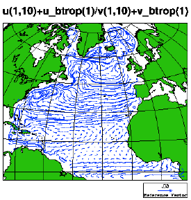
Total surface current
This figure displays the sum of the baroclinic mode upper level current and the barotropic mode (depth mean) current, both extracted at time step no. 10:
Svector.sh 4dmap hycom_031_uv.nc u v u_btrop v_btrop 1 10
Svector.sh: syntax
Svector.sh --help

           Svector.sh  /  ncl-metno 1.2

>>>
>>>
>>> Syntax:
>>> =======
>>>
>>>  Svector.sh <option> <file> <u> <v> <u_bt> <v_bt> [<d3node> (<d4node>)]
>>> where
>>>    <option>    specifies dimensions and geo- or nongeo-grid
>>>                 implemented:
>>>                  [234]d    - [234]D fields
>>>                  [234]dmap - [234]D fields, dims. are lon & lat
>>>                  ...[234]dmap will be displayed on a geogr. map
>>>    <file>      name of the netcdf file
>>>    <u>         name of variable w/ baroclinic velocity in the x-direction
>>>                 on the netcdf file (case sensitive)
>>>    <v>         name of variable w/ baroclinic velocity in the y-direction
>>>    <u_bt>      name of variable w/ barotropic velocity in the x-direction
>>>    <v_bt>      name of variable w/ barotropic velocity in the y-direction
>>>    <d3node>  node no. of third dimension
>>>                if <option> is one of 2d, 2dmap and a fourth
>>>                  argument is present, or if <d3node> is negative,
>>>                  this will be interpreted as a flag that will cause
>>>                  the ncl script to remain
>>>    <d4node>  node no. of fourth dimension
>>>
>>>  The script will produce an eps-file and a png-file.
>>>
>>>
>>> User specifications:
>>> ====================
>>>
>>>  By copying the default spec.s from
>>> /home/arnem/lib/ncl-metno/userdef.ncl
>>>  to the directory where the command 'Svector.sh' is given,
>>>  the user may specify
>>>   * title
>>>   * font
>>>   * zooming
>>>   * vector spec.s (size, distance, curly/regular vectors)
>>>   * plot size limits
>>>   for geographical maps:
>>>   * names of longitude & latitude variables
>>>   * map projection
>>>   * coastline detail level
>>>   (look up, or copy, this file to edit your own 'userdef' file).
>>>
>>>
>>> Example:
>>> ========
>>>
>>>  Svector.sh 4dmap hydrography.nc u v u_btrop v_btrop 1 10
>>>    will produce vectors on a lon-lat grid w/ a map, of
>>>     the sums 'u'+'u_btrop' and 'v'+'v_btrop' in the
>>>     x- and y-directions, respectively; 'u' and 'v' will be
>>>     extracted at the first first node in the third dimension
>>>     (usually the top vertical level) and the tenth node in
>>>     the fourth dimension (usually time step no. 10),
>>>     whereas 'u_btrop' and 'v_btrop' are extracted at the
>>>     tenth node in their third dimension; all variables
>>>     will be read from the file 'hydrography.nc'
>>>
>>>
>>> Terminating.