shell scripts:
layersection.sh
Syntax
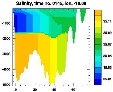
Example: Meridional cross-section of salinity
The figure below was made by issuing the command:
layersection.sh hycom_031_h.nc hycom_031_TS.nc thknss salin lat 62 145
layersection.sh: syntax
layersection.sh --help

        layersection.sh  /  ncl-metno 1.2

>>>
>>>
>>> NOTE: This script assumes that the variable to depict has been
>>>  stored with dimensions in the order x  -y  -layer(-time)
>>>                                   or lon-lat-layer(-time)
>>>  (w/ Fortran style sequence of dimensions).
>>>
>>> Syntax:
>>> =======
>>>
>>>  layersection.sh (layer) <hfile> <varfile> <hname> <varname>\
>>>                                            <dimname> <node> <time>
>>> where
>>>    (layer)     include an initial argument 'layer' if you want isopleths
>>>                 to be drawn for layer interfaces, ignore otherwise
>>>    <hfile>     name of netCDF file w/thickness results
>>>    <varfile>   name of netCDF file w/requested variable
>>>                 you may use '.' if both variables are on the same file
>>>    <hname>     name of thickness variable
>>>    <varname>   name of variable to depict
>>>             NOTE! This script requires the existence of an
>>>                   attribute 'missing_value' to <varname>
>>>    <dimname>   name of crossection's horizontal dimension
>>>                 e.g.,  lat  for a lat-z (meridional) crossection
>>>    <node>      node of non-depicted dimension
>>>                 if <dimname> is  lat , this is the  lon  grid no.
>>>    <time>      time step no. to depict (use  0  for x-y-z & lon-lat-z fields)
>>>                a negative <time> value is interpreted as a flag that
>>>                 stops the ncl script from being deleted
>>>
>>>  The script will produce an eps-file and a png-file.
>>>
>>>
>>> User specifications:
>>> ====================
>>>
>>>  By copying the default spec.s from
>>> /home/arnem/lib/ncl-metno/userdef.ncl
>>>  to the directory where the command 'layersection.sh' is given,
>>>  the user may specify
>>>   * title
>>>   * font
>>>   * zooming
>>>   * color map (palette)
>>>   * no. of colors
>>>   * plot size limits
>>>   (look up, or copy, this file to edit your own 'userdef' file).
>>>
>>>
>>> Examples:
>>> =========
>>>
>>>  layersection.sh hycom_expt007.nc . thknss salin lat 30 49
>>>    will produce a lat-z crossection normal to longitude node no. 30,
>>>     of the variable 'salin' on the file 'hycom_expt007.nc',
>>>     w/ layers given by 'thknss' on the same file, add isopleths for
>>>     layer interfaces, from timestep no. 49
>>>  layersection.sh hycom_expt007.nc . thknss . lat 30 49
>>>    same as above, but here, thknss is requested; this is a
>>>     special case where the layer no. will be contoured
>>>     (the thickess will correspond to the distance between layer
>>>      interfaces), isopleths for layer interfaces will not be drawn
>>>
>>>
>>> Terminating.