|
Model results for hydrography are here compared
with observations from the Hirtshals (Denmark) - Torungen
(Norway) transect. Model results were stored at the measuring
depths of the transect data. Generally, errors are reduced with
more advanced representations of the relevant processes. The
results for the fresh water height show that the modelled
salinities are too low on the Danish side and in the central
Skagerrak, whereas the salinities are too high on the Norwegian
side.
|
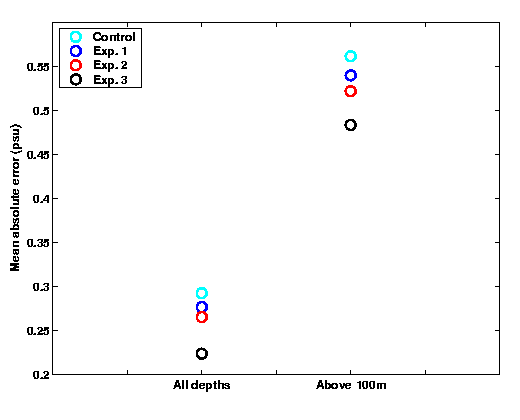
Validation of various representations of river run-off and Baltic
fluxes in MI-POM simulations, based on observations from the
Hirtshals (Denmark; to the left) - Torungen (Norway; to
the right) transect. Model results and observations are from
1998. Results from the following experiments were considered:
- Control expt.: Climatological run-off from
all rivers, and climatological fluxes of Baltic outflow to the
Kattegat
- Expt. 1: Climatological run-off replaced by
the most realistic run-off data available; still using climatological
fluxes for Baltic outflow into the Kattegat
- Expt. 2: Realistic river run-off as in
Expt. 1, but incorporating a simple analytic "Baltic reservoir"
sub-basin model for volume fluxes, with outflow salinities set to
18 PSU)
- Expt. 3: Realistic river run-off as in
Expt. 1, but incorporating results from a storm surge model for
volume fluxes, with outflow salinities set to 18 PSU)
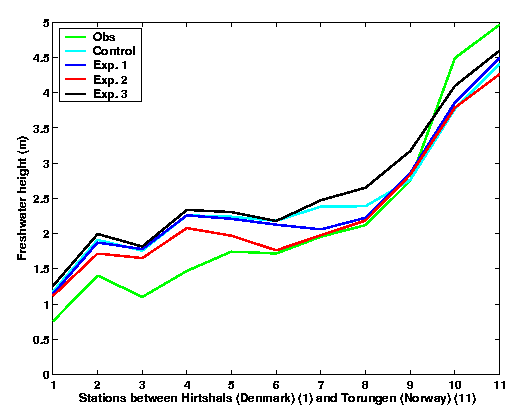
Results for the fresh water height, based on the same observations
and model results as the top panel. The fresh water height is
computed as the vertical integral of
max[S0 - S(z)]/S0
where S0 is the salinity of the water masses that are
unaffected by the regional fresh water fluxes (here, S0
was set to 35 PSU).
|